
Departments
Designating CTFN Settlement Lands in the Marsh Lake area
HLNR is in the process of considering land designations for Settlement parcels in the Marsh Lake region. The map below depicts all CTFN parcels in the Marsh Lake Local Area Plan planning area.
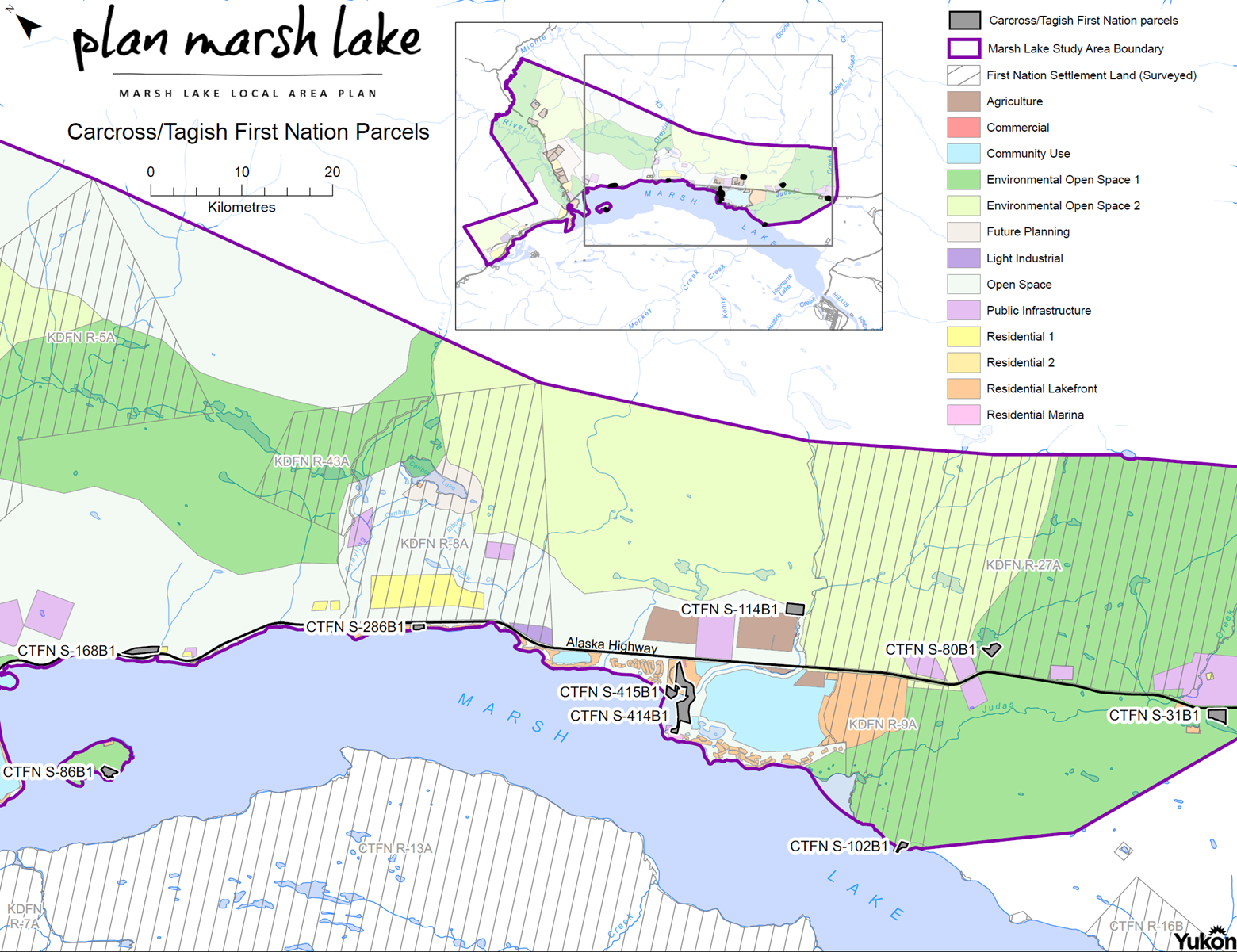
| CTFN SL Parcel | Size in ha | Proposed Designation |
| S-31B1 | 8.4 | Residential 1 |
| S-80B1 | 5.3 | Residential 1 |
| S-86B1 | 4.7 | Residential Lakeshore |
| S-102B1 | 2.2 | Residential Lakeshore |
| S-114B1 | 8.5 | Residential 1 |
| S-168B1 | 8.7 | Residential Lakeshore |
| S-286B1 | 2.2 | Commercial with residential use |
| S-414B1 | 28.2 | Residential Marina or Residential Lakefront |
| S-415B1 |
4.5 |
Residential Marina or Residential Lakefront |
Current Plan provisions for different zones
Residential 1
The purpose of Residential 1 is to establish a zone for residences located on the east side of the Alaska Highway.
- The recommended minimum lot area is 1.0 hectare.
- The primary use of the property is residential. One primary residence is permitted.
- One secondary residence (that is smaller in terms of building area, height, and occupant capacity relative to the primary residence) is permitted.
Residential 2
The purpose of Residential 2 is to establish a zone for large residential lots that are compatible, in terms of density and intensity of use, with adjacent or surrounding agriculture uses, in particular on M’Clintock Valley Road.
- The recommended minimum lot area is 3.0 ha.
- The primary use of the property is residential. One primary residence is permitted.
- One secondary residence (in terms of building area, height, and occupant capacity relative to the primary residence) is permitted.
- Minor agricultural pursuits are permitted, including small-scale commercial or personal agricultural operations that can be carried out on a small tract and are compatible with residential use. Typical uses include, but are not limited to, nurseries, greenhouses, market gardens, beekeeping, and keeping livestock for personal use.
Lakefront Residential
The purpose of the Lakefront Residential designation is to establish a zone for existing and new lakefront residential and recreational (cottages) development. This designation accounts for most of the lots on the west side of the Alaska Highway. Special consideration was given to the risk of flood and erosion, as well as public access to Marsh Lake.
The recommended minimum lot area is 0.5 hectare.
- The primary use of the property is residential. One primary residence is permitted.
- The following requirements for flood damage mitigation apply to residential and accessory structures. Land within 30.48 m of the ordinary high water mark is crown land:
- Construct liveable space or space for storage of goods damageable by flooding above the 100-year flood elevation levels.
- Undertake adequate flood damage protection and/or flood-proofing measures. This could include building on fill, provided such fill does not interfere with flood flows of the watercourse or affect neighbouring properties, and is adequately protected against floodwater erosion, using structural means to raise the building, such as foundation walls, columns, etc., or a combination of fill and structural means.
- Plans for flood damage protection and flood-proofing measures should be provided during the development permit process.
- Existing properties within an identified flood risk area are encouraged to consider flood damage mitigation measures when renovating or altering property.
- Public access to the shoreline must be maintained at all times. Private use of the public area between the shoreline and residential properties for docks or any other structure that inhibits through access is not allowed.
- Closure of a public access to Marsh Lake for any purpose must be carefully considered in the context of alternative accesses that are close to surrounding properties. If none exist, the access will remain open.
- Lake front property owners are encouraged to maintain as much vegetation as possible to help mitigate the erosion of the lakeshore. Land within 30.48 m of the ordinary high water mark is crown land and any timber harvesting in this area can only be done in accordance with the Forest Resources Act and related policies.
Marina Residential
The purpose of the Marina Residential designation is to encourage the long-term success of the marina as a facility.
The marina is considered an asset to the community and people want it to remain as a community fixture. This designation allows a variety of uses and higher density development that may provide an incentive to re-develop the property and marina.
- A mixed-use commercial/residential land use is allowed. These uses could include high-density multi-family residential, hotel, condo-hotel, and a range of commercial uses that are consistent with that of a marina.
- This site is recommended to be regulated as a Comprehensive Development Zone (CD), which provides for the development or redevelopment of a larger site, allowing a variety of land uses and development approaches as part of a comprehensive development plan.
Careful consideration of water and sewer services will be a major component of any project proposing higher density development and may be the determining factor in the allowable density.
Commercial
During the public process there were a number of different interests expressed regarding commercial development. There were others that felt residents could continue to access services and goods by commuting back and forth to Whitehorse. The balance that is presented in this Plan is to provide small commercial nodes on the highway: one in Judas Creek; and one in South M'Clintock. The Marina has also been designated Commercial, with opportunities to diversify development opportunities there. Policy has been developed to provide opportunities throughout the Residential designations for home-based businesses and bed-and-breakfast operations.
- Commercial designations on the Alaska Highway are intended for convenient services for the local and travelling public (e.g., a grocery store, gas bar, eating and drinking establishments, postal services, and office supplies).
- The recommended minimum lot area is 1.0 hectare.
- One residence is permitted as a secondary use to the principal commercial development. The commercial development must be established before residential use is permitted.
- The plan recognizes the existing zoning provisions that apply to commercial development on CTL-Tourist Lodge Zone and CRV-Recreational Vehicle Campground Zone properties in the M’Clintock Place Development Area Regulation.
Commercial developments should consider the area’s rural character in terms of building material, colours, form and scale, and site development.
Reference Documents
Marsh_Lake_Local_Area_Plan_CTFN_parcels.pdf
Descriptions_of_Plan_Designations.pdf
Submit Your Comments
Thank you for providing HLNR with feedback to the proposed designation of CTFN Settlement Land parcels.
Are we getting it right?
Do you have a particular interest in a parcel in the Marsh Lake area?
We truly appreciate you getting in contact with us to ensure that we receive your advice and guidance.
Comment